Voter Administration with EFS EDGE
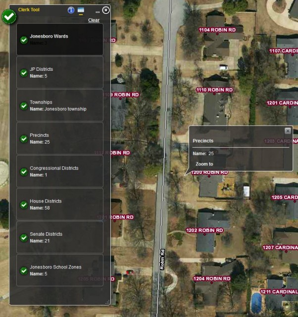
Craighead County officials continue to add EFS EDGE to their daily workflows to help them better serve the residents of Craighead County. EFS recently added their newly updated voting precincts to EDGE and received the following comment from Lesli Penny, Craighead County Deputy Clerk, “Thank you so much! We are using them today as voters have received new ID cards and all are not happy with new polling locations. Your maps make verification of addresses easier for us! Again, thank you!” EDGE allows the County Clerk’s office to not only view their voting administration boundaries with absolute detail but also use physical address point data to assist with requests from the public on which voting precinct they reside in. The moment a new address is entered into EDGE it is made viewable to the other County officials and employees who have access to the system. Voter administration is handled through the Clerk Tool which allows for all Voting Districts to be listed for any given location by a single click of the mouse.
EFS GeoTechnologies is an Aerial Photography and GIS Services company based in Monticello, Arkansas. To learn more about EFS please visit www.EFSGEOTECH.com. Also, to receive updates from EFS you can follow them on Facebook and Twitter.
April 27, 2014 Arkansas Tornado Response
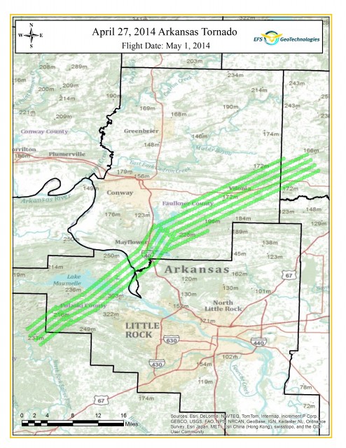
Sunday, April 27, 2014 a strong EF4 tornado struck central Arkansas and caused 15 fatalities in Pulaski, Faulkner, and White County Arkansas. The hardest impacted areas were the cities of Mayflower and Vilonia, Arkansas.

Thursday, May 1, 2014 EFS tasked one of its aerial photography collection aircraft to Central Arkansas to collect high resolution aerial photography of the impacted areas. This data will be usefull in the recovery process for mapping of damaged property.
Digital Aerial Photography products available from today’s flight are:
- One Foot Resolution Orthophotography of the area highlighted green in the map above.
- Half Foot Resolution Orthophotography of the cities of Mayflower, Vilonia, and El Paso
- Images may be delivered in Natural Color (RGB), Color Infrared (CIR), or Both (RGB-NIR)
Please contact EFS GeoTechnologies for information on any of the above products. Also, samples from today’s flight will be made available soon on our Facebook Page.
EFS GeoTechnologies is an Aerial Photography and GIS Services company based in Monticello, Arkansas. To learn more about EFS please visit www.EFSGEOTECH.com. Also, to receive updates from EFS you can follow them on Facebook and Twitter.
Craighead County Public EDGE GIS Goes Live
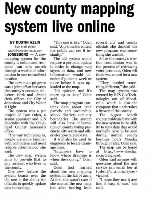
EFS GeoTechnologies is excited to see our technology being shared with the public. EFS has been working with Craighead County and the City of Jonesboro, Arkansas for several years. This year they decided that along with Aerial Photography they wanted to start working with our EDGE GIS to make their GIS data available to City and County users the instant it is created or updated. The article below is from the Jonesboro Sun Newspaper. To see the Craighead County EDGE public viewer go to www.efsedge.com/craighead.
EFS GeoTechnologies is an Aerial Photography and GIS Services company based in Monticello, Arkansas. To learn more about EFS please visit www.EFSGEOTECH.com. Also, to receive updates from EFS you can follow them at Facebook and Twitter.
Monticello Water Repairs

Deteriorating Water System: Where Do I Start?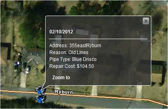
Upon election the Mayor of Monticello, Allen Maxwell, quickly realized the issue he inherited with a deteriorating water system. For many years Monticello Water Department Employees were tasked daily with patching the leaking water system. Mayor Maxwell envisioned a system where he could quickly and easily visualize where the water leaks were occurring so he could make a case for the replacement of the old deteriorating pipes. Through a partnership with a local GIS company, EFS GeoTechnologies, the two entities began developing the system below. The Monticello Water Repairs database was developed with the EFS’ EDGE GIS. EDGE allows for quick, easy visualization and analysis of the water leak locations mapped by Monticello Water Department Employees using EFS’ EDGE for Field Data Collectors solution. This allowed the visualization of the data for replacement of pipes instead of patching and ultimately led to making a case for the replacement of Monticello’s old water system.
60% 0f leaks in 19% of City Area.
Results:
- Magnitude of Leak Problem Realized
- Targeted Areas for Line Replacement versus Leak Repair
- Following a comprehensive 2 year study, the City entered into a $10 Million Performance Contract with Siemens Industry, Inc to upgrade the Water System
- Additonal Projects: Utilized EDGE for Fire Hydrants, Bulk Trash Dumpsters, Trash Truck Routing & Airport Obstructions
EFS GeoTechnologies is an Aerial Photography and GIS Services company based in Monticello, Arkansas. To learn more about EFS please visit www.EFSGEOTECH.com. Also, to receive updates from EFS you can follow them on Facebook and Twitter.
Arkansas Assessors’ Fall Conference 2013
Arkansas Assessors, stop by EFS GeoTechnologies’ booth at the upcoming Fall Assessors’ Conference at the Double Tree Hotel in Little Rock, Arkansas, November 5-8. Auddy Doss and Michael Gilbert will be attending the conference and will be available each day to discuss your Aerial Photography and GIS/Mapping needs. For over 26 years EFS has provided High Resolution Aerial Photography and GIS services. EFS is your LOCAL in state provider of these services and count it an honor to work with Arkansas Counties in designing a program for Aerial Photography and GIS. Along with Aerial Photography be sure to ask about updates to EFS EDGE and our new EFS EDGE Mobile app. EDGE allows for the sharing of GIS data across multiple county offices and provides options for the maintenance of your Parcel maps and other GIS data. The EDGE website was designed especially for Arkansas counties. The EDGE Mobile app can be configured as a mobile solution for your staff as well as an avenue to share your work with county constituents. Auddy and Michael look forward to having the time to visit with friends and hope to make new friends as well.
EFS GeoTechnologies is an Aerial Photography and GIS Services company based in Monticello, Arkansas. To learn more about EFS please visit www.EFSGEOTECH.com. Also, to receive updates from EFS you can follow them at Facebook and Twitter.
GITA Conference 2012
 |
 |
||
|
|||
|
|||
|
EFS GeoTechnologies | P.O. Box 90 | 360 Airport Road | Monticello, AR 71657 |
|||
Dabney Reappointed to AR State GIS Board
 The Arkansas Geographic Information Office (AGIO) announced Wednesday Glen E. Dabney, R.F., A.C.F. President of EFS GeoTechnologies, was appointed to a second term on the Arkansas GIS Board by Governor Mike Beebe. The Arkansas GIS board, comprised of twelve members from state and local government, the private sector, and institutions of higher education, works with the AGIO to coordinate GIS activities within the state. Mr. Dabney was appointed to his first term in 2008 and has served as an advocate for the private sector and free enterprise system during his service to the board.
EFS GeoTechnologies is an Aerial Photography and GIS Services company based in Monticello, Arkansas. To learn more about EFS please visit www.EFSGEOTECH.com . Also, to receive updates from EFS you can follow them at Facebook and Twitter.
Welcome to the New EFSGEOTECH.COM

EFS GeoTechnologies is proud to unveil its new website. The new EFSGEOTECH.COM will allow for news, information about products and services, as well as samples from recent projects to be showcased through the web. Please take a moment to review the pages of the new website and visit often. On the Contact Page you will find a form to request information from EFS as well as links to our Facebook and Twitter Pages.
City of Monticello Arkansas uses EFS’s EDGE Technology
Aug. 2012 – Below is a link to a recent article detailing how the City of Monticello, Arkansas is using our EDGE system to manage their water system and more particularly to show where the water leaks are. The video included has a portion of the city using EDGE in a City Council Meeting. It also has some photos of EDGE being used.


